-
Given the nature of the quandary raised above, research on the earliest phases of Earth history continues today. Simon Wilde and co-authors published a key data set in this investigation with their paper “Evidence from Detrital Zircons for the Existence of Continental Crust and Oceans on the Earth 4.4 Gyr Ago” (Nature, 2001). As the title alludes to, Wilde and co-authors successfully applied the uranium-lead method to date the oldest terrestrial object ever discovered: a single zone of a single shard of the mineral zircon that is 4.4 billion years old. The image on the left shows that zircon with several different spots created by the device used to make the measurement. The incredibly small scale (see the inset scale bar) at which this work is performed requires sophisticated machinery, and the images on the wall above this case features instrumentation in the Department of Geology that is used to conduct current geochronologic research. The oldest rock yet dated is 4 billion years, the oldest mineral is 4.4 billion, and the oldest building material is 4.55 billion. Indeed, the “abyss” of deep time is vast, but importantly not “infinite” nor completely “unrecorded."
-

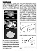
Following the foundational work of Marie and Pierre Curie and Henri Becquerel, Ernest Rutherford and Frederick Soddy derived the empirical and mathematical principles of radioactivity in their seminal paper “The Radioactivity of Uranium” (Philosophical Magazine, 1903). The figure displayed here demonstrates how the “parent” element uranium is transformed into the unknown “daughter” element “uranium-x” (since identified as 234Th). Both curves are exponential and perfectly mirror one another, which reveals that the process of radioactive transformation occurs at a constant rate. From these measurements, Rutherford and Soddy described the fundamental principles of the radioactive decay constant, half-life, and parent-daughter ratios. Because the decay rate for a given pair of parent and daughter elements was a universal constant, the measurement of the ratio between parent and daughter in any mineral would reveal the age of that mineral.
-
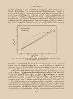
The centerpiece of this section is the Clare Patterson study “Age of Meteorites and the Earth” (Geochimica et Cosmochimica Acta, 1956) that marked the Earth as 4.55 billion years old; an age that has stood ever since. The elegance of Patterson’s approach is revealed by the simple lines drawn on the graph shown here. The two axes of the graph are ratios of different varieties or “isotopes” of lead. Each isotope has the same number of positively charged protons (hence, defining the element as lead) in the atomic nucleus, but a slightly different number of neutrally charged neutrons. The 82 protons, plus the numbers of neutrons that range from 122 to 125, give the different isotopes of lead their names: 204Pb, 206Pb, and 207Pb. The number of atoms of 204Pb is constant throughout time, but the number of atoms of 206Pb and 207Pb has been steadily increasing since the Earth first formed as different isotopes of uranium have undergone radioactive decay. Patterson’s great insight was that, if he analyzed the different amounts of 204Pb, 206Pb, and 207Pb in different meteorites, the primordial building blocks of planets, then their lead ratios should fall on a straight line, with the slope of the line providing the age of the Earth. Patterson regressed two lines, one that gave an age of 4.6 billion, the other 4.5 billion. He split the difference and arrived at 4.55 billion. Patterson’s age raised intriguing questions of its own though, because he was providing an age for Earth’s building material (meteorites), not directly the age of the Earth itself. Put in another fashion, is it appropriate to think of the age of a building as when it is finally completed, or rather when its first corner stone is laid?
-
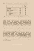
After Rutherford first demonstrated the incredible promise of radiometric dating in 1905, the geochronologist Arthur Holmes applied the technique widely throughout a long and prolific career. His approach focused on the parent-daughter pair of uranium and lead, and his measurements of lead and uranium ratios were global in scope. The table shown here from his paper, “The Association of Lead with Uranium in Rock-Minerals, and its Application to the Measurement of Geological Time” (Proceedings of the Royal Society of London, 1911), represents an early result. The most striking features of this table are the antiquity of the listed ages, particularly the “Pre-Cambrian” ages that stretch into the billions of years. Such numbers greatly exceeded any of Lord Kelvin’s calculations. Holmes later estimated, from these and other results, that the Earth was 1-3 billion years old, a number that was of the correct order of magnitude for the consensus age used by modern geologists.
-
In the same year that Walcott published his influential calculation for the age of the Earth and its eras, Henry Williams proposed, in his “Studies for students: the elements of the geological time-scale” (Journal of Geology, 1893), the new science of “geochronology”. This new discipline would encompass studies “in which the geological time-scale is applied to the evolution of the earth and its inhabitants” with a clear distinction between time concerned with “human chronology” and “geochronology”. Using a similar approach to Walcott, Williams attempted to bring quantitative rigor to the time-scale with the concept of a “geochrone”. His table shown here relates one “geochrone” to the duration of sediment deposition for the Eocene Epoch, and all other eras are ratioed to this unit. As with the other examples shown in this section, Williams’ methods were, as recognized at the time, inadequate to the task at hand. Yet they collectively show a growing desire to place absolute numbers on a hitherto relative history.
-

Debates about the accuracy of Lord Kelvin’s estimate for the age of the Earth spurred an alternative approach among geologists that relied upon calculations of the rate of sediment accumulation and erosion. This method was less theoretical, and used direct observation and measurement, but still contained a large amount of assumption and conjecture. Charles Walcott illustrates the method here in “Geologic time, as indicated by the Sedimentary Rocks of North America” (Journal of Geology, 1893). The table shows the periods of Earth history with accompanying estimates of their duration. Walcott and others were drawing upon a practice that stretched back at least to the studies of sediment accumulation in the Rhine and Nile River deltas by Jean Andre de Luc and Déodat Dolomieu, respectively, and erosion of volcanic valleys in Auvergne by Nicloas Desmarest. The key difference was that Walcott’s scope was global, whereas the studies of these earlier savants were local. Ironically, Walcott’s total estimate for the age of the Earth is nearly the same as the one derived by Lord Kelvin; however, Walcott’s estimate yielded more detailed information about the longevity of each period. The ratios of their durations (except for the Archean and Algonkian) are surprisingly similar to ones accepted by modern geologists.
-
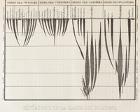
This diagram from Louis Agassiz’s Fossil Fish (Poissons fossils, 1844-1845) reflects the consensus view (with the notable exception of Charles Lyell) by the mid 19th century that the fossil record showed an Earth through time that was directional and historic as opposed to uniform or steady-state. The “Genealogy of the Class of Fish” was an innovative approach to depicting the changes in abundance of certain species through time, although it owed much to previous similar statistical approaches by Heinrich Bronn and Gerard-Paul Deshayes. Agassiz here created “spindle” charts that pinch and swell to give the impression of increasing and decreasing relative fossil abundance, and branch towards the present to show either the increasing complexity of life, or the sudden appearance of a new genealogy. Although this looks to the modern eye very much like an evolutionary history of fish life, it notably predates Charles Darwin’s On the Origin of Species (1859).
-
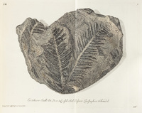
The images shown here from Georg Knorr and Emmanuel Walch’s Collection of Remarkable Natural Objects (Sammlung von Merckwurdigkeiten der Natur, 1755-1775) are typical of the “paper museum” approach to fossils in the mid-18th century. The specimens are devoid of their location or rock context, but exquisitely detailed, which aligns with the focus on classification and taxonomy as opposed to geohistory. Although Knorr and Walch’s illustrations were used in this narrow sense when they were first published, they did inspire later savants in the early 19th century. The fossil plants shown here were the subject of study for Ernst Friedrich von Schlotheim, who identified fern species in the Coal formations of Europe that were clearly terrestrial, extinct, and representative of a former world quite different from modern Europe. In 1828, Adolphe Bronginart (son of Alexandre) would take the geohistorical importance of these plants a step further when he created a directional progression of European fossil plants that showed changing environmental conditions through time: tropical ferns in the “lower Secondaries” (i.e. Carboniferous, 359-299 million years ago), sub-tropical Gymnosperms of the “upper Secondaries” (i.e. Mesozoic, 252-65 million years ago), and temperate Angiosperms in the “Tertiary” (i.e. Cenozoic, 65-0 million years ago).
-
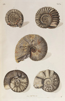
Another volume of Knorr and Walch’s Collection of Remarkable Natural Objects (Sammlung von Merckwurdigkeiten der Natur, 1755-1775) is shown here, with a focus on a class of mollusks called ammonites. These extinct animals are most closely related to the extant nautilus, but differ in their ridged shells, which are shown here in great detail. Persuasive arguments were made at the time of this publication that the ammonites were not truly extinct, but merely waiting to be discovered in some far-off corner of the globe. By the 19th century, the consensus view was that ammonites were in fact extinct, and that the Secondary units in which they were found represented a distinctive time in Earth’s history. Ammonites were used by savants such as Giovanni Brocchi and Alexandre Bronginart to distinguish the older Secondary units (ammonites present) from the younger Tertiary units (ammonites absent), and they continue to be used in this manner by modern geologists.
-
An early and influential example of the geotheory approach to calculating an age of the Earth was carried out by Georges-Louis Leclerc (Comte de Buffon). This section displays several tables from Buffon’s Historie Naturelle, Generale et Particuliere (1775), which consisted of experiments to determine the cooling rate of various molten metallic spheres. In his second of two geotheories, Buffon used these empirical measurements to estimate the time required to cool a molten Earth to the solid one we observe today. His estimate was on the order of 100,000 years. This number is far younger than the widely accepted, modern measurement of 4.55 billion years, but Buffon’s theory contained two crucial aspects that separated it from other geotheories of the time. First, the theory achieved a middle ground between an Earth that was only a few millennia old, and one that was infinite. Second, it inferred a directional nature to Earth’s history, with a beginning (molten sphere) and eventually end (frozen, lifeless world).
-
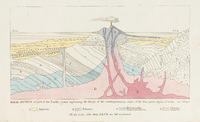
The potential for interpreting the historical nature of Earth’s layers was fully realized in the monumental work of Georges Cuvier and Alexander Brongniart in the Paris Basin. Cuvier and Brongniart’s diagrams, shown here in Recherches sur les Ossemens Fossiles de Quadrupedes (1812), accomplished several related research objectives that were scientific firsts. The “ideal section” shown as “Fig. 3” organizes layers not only by rock type but crucially by fossil assemblages (e.g., cerithes, huîtres, and ossements). The identification of these assemblages allowed the authors to correlate units across large lateral distances, shown here in the central figures that stretch across the entire Paris Basin. The ideal section also contains the paradigm shifting observation, again gathered from the fossil evidence, that the Paris Basin had alternated between periods of marine and freshwater (terrain d’eau douce). This insight revealed that geologic layers could provide a unique history of the different environments, or previous worlds, experienced at a given location. That is, the temporal character of Earth was decidedly not composed of indistinguishable, endlessly repetitive cycles, nor a unidirectional model of progressively falling sea levels.
-
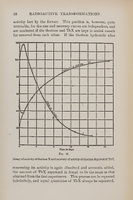
Ernest Rutherford compiled the various advances he and his collaborators had achieved into the book Radioactive Transformations (1906). This text shows a similar graph as seen in The Radioactivity of Uranium, with a different set of elements. The two graphs are remarkably similar, which underscores the universal application of Rutherford and Soddy’s principles. Modern geochronologists avail themselves of a wide variety of radioactive elements found in different minerals, all with different constants and half-lives that are suited to a specific geologic problem.
-
James Hutton presented this drawing of an angular “junction” (i.e., unconformity) between layers of the Earth near Jedburgh, Scotland as evidence for his Theory of the Earth (1788). Hutton’s illustration is another example of a pre-19th century, ahistorical approach to interpreting geologic layers. He viewed this scene as supportive of an endlessly repetitive cycle in which the older layers were tilted and eroded to form new material for the younger layers. This theory clearly has temporal aspects, but it lacked any sense of directionality in the overall sequence, or distinctiveness to each discrete layers; that is, historical context. For Hutton, there was “no vestige of a beginning, no prospect of an end.” This famous phrase should be understood in a literal sense: the Earth is eternal, with no beginning, no end, and no unique history for any given cycle. Hutton’s arguments placed him on the opposite end of the intellectual spectrum from those that proposed an Earth that was only a few millennia old (e.g., Ussher), which garnered criticsm from savants that sought a middle path: an exceptionally old Earth with a finite history.
-

Jean Andre de Luc also proposed a distinct theory of the Earth in his Physical and Moral Letters (Lettres physiques et morales, 1778). This theory was biblically influenced, but as with the other texts presented in Religious Chronologics, future scientific approaches to Earth history drew insights from de Luc’s work. De Luc argued for a binary model of Earth history, split between a relatively short span of human history as defined by the old testament, and a vastly longer span (de Luc was not a biblical literalist) of pre-human history. The great divider, or revolution, was Noah’s deluge, but the accuracy of the model is less important in the context of this exhibit than the idea that nature had a history of its own, separate from human records and witness. In addition, it was de Luc that first proposed the name “geology” for this field of inquiry, and (notably before James Hutton) that an understanding of the time scales for Earth’s history should rely upon observations of “actual causes” (i.e., the present is the key to the past).
-
Buffon’s initial method of age determination was continued and refined in the 19th century by William Thompson (Lord Kelvin). Kelvin used the same basic approach and set of assumptions, albeit with more sophisticated heat loss calculations, to arrive at an initial estimate of 100 million for the age of the Earth, which he later whittled down to 20 million years. This case shows an excerpt from Kelvin’s Treatise on Natural Philosophy (1867) that explain his method and contains various calculations for the age of the Earth that range between 20 and 100 million years. Most geologists of this time, from their observations of actual causes, suspected that this age was too young, but lacked the convincing evidence necessary to counter Kelvin’s estimate. As such, the range of 20-100 million years became a widely accepted, yet debated, age for the Earth in the late 19th century.
-
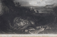
As the frontispiece for Gideon Mantell’s Wonders of Geology (1839), John Martin drew a geohistorical scene that depicts the ancient reptilian iguanodon, which Mantell had recently discovered in the Weald region of southeast England. This illustration is based in part on direct field observations and reconstructions from the rock record of the iguanodon’s ancient environment, as we can see depicted by the estuary in the background. But the image sacrificed a degree of scientific accuracy (Mantell had accurately identified iguanodons as herbivores) to create a more dramatic scene that would boost book sales. The dual objectives of this sketch show the power of geohistory in the early 19th century to both retrodict former worlds and capture the public imagination.
-
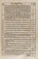
James Ussher, in Annals of the Old Covenant (Annales Veteris Testamenti, 1650-54), calculated a figure of 4004 B.C. for the start of all time (i.e., “The Creation”). The text displayed here highlights his method in the margins of each page, with the date of each event, birth, or death calculated from the longevity of each generation, listed to the left or right of the corresponding biblical verse. This age has become the most (in)famous of the figures calculated by early chronologists, but it was one of dozens of short timescales proposed by analysists of historical textual records, with most deriving an estimate of only a few millennia for the age of the Earth. By the 18th century, the consensus view of most savants, and certainly all of those featured in this exhibit, was that this timescale was wholly inadequate to explain the growing evidence collected by natural historians. Yet Ussher’s calculation and methods, and others like it, served as both an intellectual opposite endmember to proposals of an infinite world (see James Hutton in History in the Layers), and spurred influential savants, most notably Georges Cuvier and William Buckland, to attempt to link Earth’s history in deep-time to the textual events in human history (e.g. the Deluge of Noah).
-
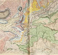
The work of William Smith, Strata of England and Wales (1815) is the example par excellence of the new ability to tie rock units together across vast areas by observing their characteristic fossils. Smith coined the phrase “stratigraphy” to describe his approach, which is shown here in beautiful detail with common colors to infer the contiguous nature of these rocks from isolated outcrops. Although the various colors seen on Smith’s maps extend across entire regions, the rocks themselves could only be observed in a handful of places. And yet Smith, through his observations of common fossils in similar rock types, could infer that these rocks were spatially continuous; they shared a common history. Despite similarities in the approaches of Smith and that of Cuvier and Brongniart, important differences deserve some attention. Whereas Smith was only interested in the use of fossils as correlation tools, the latter two pursued the additional objective of detailing the environments of past worlds as revealed by the fossils present in the layers. A reproduction of the full map accompanies this case on the wall to the left (citation: Smith, William, and John Cary. William Smith 1815 Geological Map: a Delineation of the Strata of England and Wales…. [London]: Reproduced by the British Geological Survey, 2013. Call Number: Map Library G5751.C5 1815.S6 2013.)
-
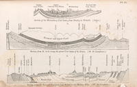
William Buckland and his Oxford compatriot and collaborator William Conybeare were early adapters of the newly emerging science of “stratigraphy”. The phrase was derived from William Smith’s work (see Maps and Cross-Sections), but could be equally applied to the new methods of investigating the Earth’s layers conducted by Cuvier and Brongniart in the Paris Basin. In a paper first published in 1822, but reproduced here in Buckland’s Geology and Mineralogy considered with reference to Natural Theology (1836), Buckland and Conybeare applied stratigraphic principles (i.e., the use of fossils to classify distinct rock layers) to the Bristol coalfields of southwestern England. An important discovery was that several unique episodes of folding and erosion had occurred within the Secondary units, highlighting a distinct and complex history for a specific region. The more accurate details of the layers at depth, as well as the geohistorical significance of this figure, highlights important advancements since the earlier Whitehurst image.
-
A personal proof of James Hutton’s Theory of the Earth, with the author’s writing.
-
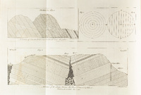
This figure from John Whitehurst’s Inquiry into the Original State and Formation of the Earth (1786) highlights the typical mid-18th century approach to observing Earth’s layers through an ahistorical lens. Whitehurst focuses his figure here, as well as imagery in the rest of the text, on characterization of the Earth’s layers (or, its “structure”), with limited and highly speculative insight into the dynamic and historical processes that created this structure. Note the mine shaft shown on the right side of the figure, which firmly situates Whitehurst’s intellectual endeavors in the applied and practical field of geognosy (the characteriziation of Earth’s structure and composition), and devoid of geohistorical context. The angled layering here required at least some ad hoc explanation, and Whitehurst illustrates his interpretation as the result of collapse along a hidden crack; a modern structural geologist would connect the two opposite sides into a single U-shaped fold. At the time of this publication, key questions of when did the tilting happen and what drove the tilting remained unanswered.
-
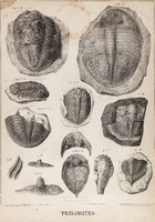
Following his classic work in the Paris Basin (see History in the Layers of the Earth), Alexandre Brongniart continued to investigate and establish the principles of geohistorical investigation with works such as his Natural History of Crustacean Fossils (Histoire naturelle des crustacés fossiles, sous les rapports zoologiques et géologiques, 1822). In the image shown here, Brongniart focused on the peculiar trilobites, an extinct marine arthropod that somewhat resembles the extant horseshoe crab. He demonstrated that the “transition” rocks that hosted these fossils, represented a quite different and stranger world than our modern one. Trilobite species still serve a crucial role in modern Earth sciences for delineating the Cambrian period of the geologic record (542-485 million years ago).
-
Charles Lyell, through the publication of his Principles of Geology (1833) and Elements of Geology (1838), became a dominant figure in mid-19th century geology. With these two works, Lyell built upon the earlier theories of Hutton and proposed the Earth as a steady-state system that operated upon the principles of actual causes. He also set himself against the emerging school of thought that argued for a directional Earth history punctuated by various “revolutions”. This debate was classified by William Whewell as one between “uniformitarians” like Lyell, and “catastrophists” like Buckland. Both sides agreed that actual causes were the best methods to use in reconstructing the geologic past, but the key difference was the extent to which the present day causes had always operated at their current intensity throughout all of geologic time. A second important difference was the cyclical and steady nature of Lyell’s principles, which included his proposal that the recently discovered Jurassic reptiles could someday return to inhabit the Earth. One such cycle is shown here in the frontispiece to Elements of Geology. The image shows that all classes of rocks (A, aqueous or sedimentary; B, volcanic; C, metamorphic; D, plutonic) are being formed at the present and repeat earlier phases of the same rock types (lower case letter).
-
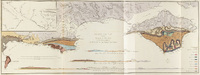
In his work with Henry Englefield, Thomas Webster applied the new geohistorical mapping approach to the Isle of Wight (A description of the principal picturesque beauties, antiquities, and geological phenomena of the Isle of Wight, 1816). Webster made several key observations in his map and cross-section of the Isle, both displayed here, that extended Cuvier and Brongniart’s stratigraphy from the Paris Basin across the Channel. First, he recognized units above (and therefore younger) than the oldest Secondary layer (the “Chalk”) that had similar fossils to those identified in the Paris Basin. In addition, both the Secondaries and the younger units were tilted and folded, which revealed a history of buckling that was both unique to the Isle, and very recent relative to the age of the Secondaries. Finally, Webster correlated his “Isle of Wight Basin” with the Paris Basin to interpret similar environments, both marine and freshwater, that must have extended across the present-day Channel at some point in the past. Webster’s discovery that the units above the Chalk had continental-scale coverage would eventually lead to the organization of a new delineation of geologic time, which Alexandre Brongniart, borrowing from Giovanni Brocchi’s classification, would refer to as “Tertiary”.
-
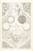
Thomas Burnet, in Sacred Theory of the Earth (1680-1689), coined the phrase “Theory of the Earth”, although his was “Sacred” and not the first attempt to deduce the workings of the Earth from physical principals. Burnet’s theory was biblically based, but decidedly not literal, and contained elements that would later be expanded upon by future savants. Notably, Burnet proposed a finite Earth that had both a beginning and end, and experienced successive Epochs or revolutions (shown on the frontispiece of the volume), which implies a degree of directionality to this particular theory of the Earth. Although religious in terms of ultimate causes for the origin of the Earth, Burnet stressed the importance of considering only natural processes in deducing Earth’s past and future state.